Canopée Gestão Ambiental is standing out in the carbon credits market through the use of advanced technologies for monitoring and analyzing geographic information in real time. The company has its own platform developed especially for geoprocessing data, mapping forest areas and monitoring carbon stocks. This provides a detailed view of the environmental preservation projects that are being carried out.
What is Geotechnology?
Geotechnology is a field of study that uses the geographic location of objects and phenomena to develop solutions applicable to daily activities, productive sectors and public policies. This area is based on specific techniques and methodologies, where data is represented by coordinates (such as latitude and longitude) and related to a geodetic reference system. To collect this data, different equipment is used, such as GNSS receivers, sensors on satellites, aircraft and unmanned aerial vehicles (UAVs). In addition, Geotechnology has a comprehensive technological infrastructure, including hardware, software, applications, algorithms and programming languages, for the processing and analysis of this geographic information.
Within the scope of Canopée Gestão Ambiental, geotechnology and geoprocessing play a fundamental role in the mapping and monitoring of forest areas. The company uses advanced remote sensing technologies and geographic information systems to create detailed maps and monitor changes occurring in these regions over time. This approach enables more efficient and accurate management of environmental preservation projects, ensuring adequate protection of forests and the correct quantification of carbon credits.
Precise survey
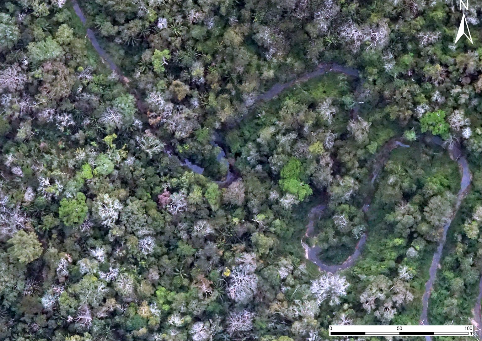
In the project development process, Canopée uses drones equipped with high-resolution cameras and LiDAR laser sensors to conduct a precise survey of the biomass of the forests to be preserved. This advanced technology allows us to perform a kind of “scan” of the forest areas, collecting data with unprecedented precision and detail.
The drones fly over the mapped areas, capturing high-resolution images and taking 3D measurements based on the LiDAR sensor data. This provides us with valuable information on tree height, vegetation density and other aspects relevant to estimating the carbon stock present in these areas.
Based on this collected data, our team is able to perform precise and detailed analyses, reliably determining the amount of carbon stored in the forests. This information is essential for the correct quantification and certification of carbon credits, ensuring the effectiveness of environmental preservation projects developed by Canopée.
Historical Analysis and Identification of Changes
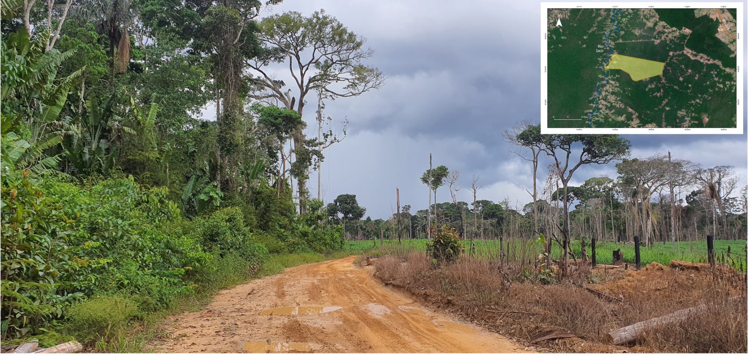
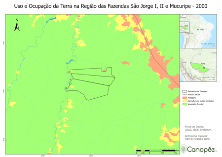
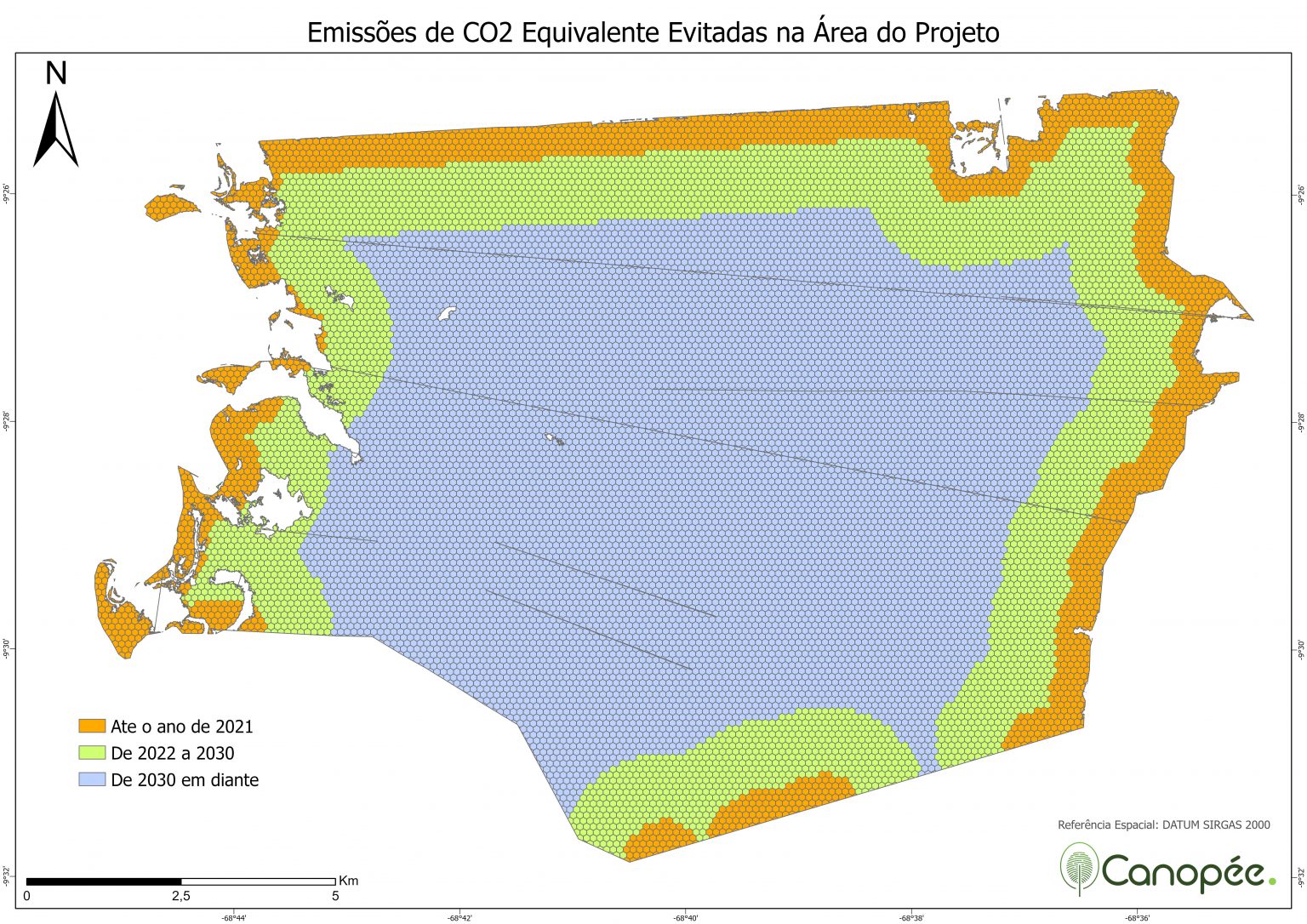
In addition to the biomass survey, Canopée conducts a historical analysis of deforestation and land use changes in the regions surrounding each project. This analysis is essential to obtain international certifications and demonstrate the positive impact we are having on the preservation of areas threatened by accelerated deforestation.
To perform this analysis, we use historical series of satellite images and an artificial intelligence system based on machine learning. This combination allows us to accurately and quickly identify changes that have occurred over time.
By processing satellite images, our system is able to detect changes in land use, identify deforested areas and monitor the progress of preservation activities carried out in our projects. This information is essential to assess the success of our actions and ensure compliance with the highest environmental standards.
After each project is developed and certified, we make the data available on a digital platform that is easy for our clients to access. To facilitate access, we include a QR code in the client's offset certificate, which directs them directly to the platform.
On this platform, clients have the opportunity to view high-resolution images of the preserved areas, which are updated annually. In addition, they can monitor the available carbon stocks in real time, through accurate and reliable data.
We believe that transparency is fundamental in our work, and that is why this digital platform was developed. This way, our clients can closely monitor the results achieved in their carbon offset projects. Continuous monitoring is an essential part of our commitment to ensuring the integrity and effectiveness of environmental preservation actions.
With this platform, we provide a transparent and interactive experience that strengthens the partnership with our customers and reinforces our joint commitment to protecting the environment.
Canopée Gestão Ambiental is a leading company in the carbon credit sector due to its dedication to consolidating environmental projects and using advanced georeferencing technologies to monitor areas under its responsibility. Our innovative methods of surveying and monitoring forest areas allow us to preserve valuable ecosystems, combat deforestation and contribute to the reduction of greenhouse gas emissions.
By combining remote sensing, drones, artificial intelligence and an interactive digital platform called Floresta Digital, Canopée offers clients not only a transparent and real-time view of the areas being preserved, but also information on the historical evolution of the project. In this way, clients can monitor the positive impact of their actions and contribute to a more sustainable future.
By combining the power of technological innovation with the preservation of nature, we are able to protect forests, combat deforestation and leave a legacy of respect and care for the environment for future generations. Our mission is to work in partnership with our clients to create a more sustainable world, where environmental preservation is a priority and economic development goes hand in hand with environmental responsibility
Av. Pres. Juscelino Kubitschek, 1455 – 4º andar 04543-011 – São Paulo / SP
Brasília - DF
Viçosa - MG
Canopée was founded in early 2020 by a small group of internationally renowned entrepreneurs and executives who decided to pool their skills and experience to benefit the environment and communities living in protected and preserved areas.